• Top Services
      • Underground Utility Installation
      • Horizontal Directional Drilling (HDD)
      • Directional Boring
      • Gas Line Installation
      • Hydro Excavation
      • Hydro Vac
      • Micro Trenching
      • Pipe Bursting
      • Pipe Splitting
      • Potholing
      • Utility Trenching
      • Underground Utility Locating
    • Areas We Service
      • California
        • Alameda County
        • Contra Costa County
        • Fresno County
        • Kern County
        • Los Angeles County
        • Orange County
        • Riverside County
        • Sacramento County
        • San Bernardino County
        • San Diego County
        • San Joaquin
        • San Luis Obispo County
        • More…
      • Arizona
        • Maricopa County
        • Mohave County
        • Pima County
        • Yuma County
    • About Us
      • About Us
      • Blog
      • Join Our Team
    • Portfolio of Recent Work
    • Cost Tools
      • Horizontal Directional Drilling Cost Calculator
      • Hydro Excavation Cost Calculator
      • Utility Trenching Cost Calculator
      • Potholing Cost Calculator
      • Gas Line Installation Cost: Calculator
      • Pipe Bursting Cost Calculator
    Contact Us
    Sign in
    Contact Us

    Drone LiDAR Surveys Coulterville Verified listing Verified listing

    Underground Utilities - Drone LiDAR Surveys Coulterville

    • Call now
    • Share
    • Profile
    • Contact Us
    • prev
    • next
    • Get directions
    • Send an email
    • Call now
    • Share
    • prev
    • next
    Description

    Drone LiDAR Surveys for Underground Utilities in Coulterville, California

    At Devco Development & Engineering, we are proud to offer advanced Drone LiDAR Surveys for underground utilities in Coulterville, California. Operating with a General A Engineering Contractor license, a General Contractor B license in California, and esteemed certifications such as DVBE, SDVOSB, PDBE, SB-Micro, and SB-PW, we bring a wealth of experience and expertise to every project.

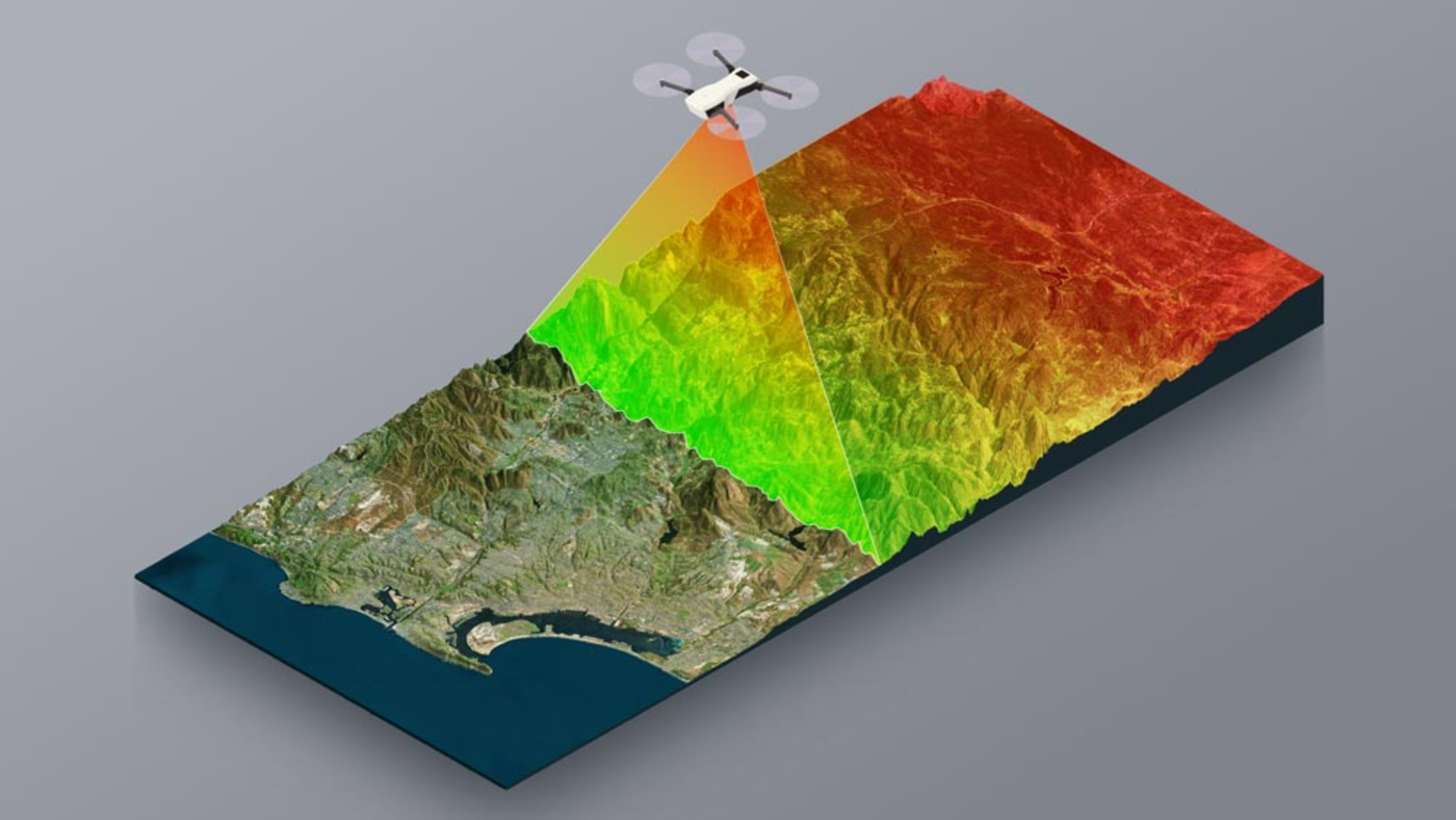
    What Are Drone LiDAR Surveys?

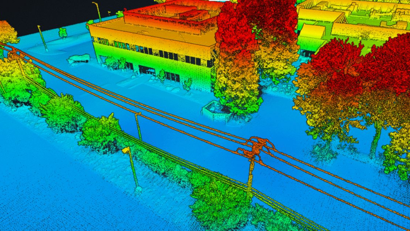
    Our Drone LiDAR Surveys utilize cutting-edge technology to efficiently map, scan, and analyze underground utilities with unparalleled precision. By combining drone technology with LiDAR (Light Detection and Ranging) technology, we can create detailed 3D models of subsurface infrastructure, allowing for accurate assessment and planning.

    The Benefits of Drone LiDAR Surveys

    • Precision Mapping: Our surveys provide highly accurate data on the location and depth of underground utilities, minimizing the risk of errors during excavation.
    • Time and Cost-Efficiency: By utilizing drones, we can conduct surveys quickly and cost-effectively, saving you valuable time and resources.
    • Enhanced Safety: Drone surveys eliminate the need for manual inspection of underground utilities, reducing the risk of accidents and ensuring worker safety.
    • Comprehensive Analysis: The detailed 3D models generated from our surveys enable thorough analysis of underground infrastructure, aiding in informed decision-making.

    Serving Mariposa County and Beyond

    Devco Development & Engineering proudly serves Mariposa County and beyond, providing comprehensive Drone LiDAR Surveys for a wide range of underground utility projects in Coulterville and surrounding areas. Whether you require surveying services for water lines, gas pipelines, sewer systems, or telecommunications infrastructure, we have the expertise to meet your needs.

    To learn more about our services or to inquire about the cost of Drone LiDAR Surveys in Coulterville, please contact us at Devco Development & Engineering.

    For inquiries, feel free to reach us at:
    - Phone: (951) 221-3633
    - Email: Info@devco-inc.com

    In conclusion, our commitment to excellence, combined with our state-of-the-art technology and extensive experience in the industry, makes Devco Development & Engineering your trusted partner for all your underground utility survey needs. Contact us today to discover how our Drone LiDAR Surveys can streamline your project and ensure its success.

    Listing Details
    • Category
      Drone LiDAR Surveys
    • County
      Mariposa County
    • City
      Coulterville
    • Contact Email
      Info@devco-inc.com
    • Phone Number
      (323) 347-3695
    • Services
      Drone LiDAR Surveys Coulterville, Survey Coulterville
    Gallery
    Location
    • Coulterville, CA, USA

      Get Directions
    Contact Form

        You May Also Be Interested In

        Gallery image Gallery image Gallery image

        Drone LiDAR Surveys Catheys Valley Verified listing

        Underground Utilities - Drone LiDAR Surveys Catheys Valley
        • (323) 347-3695
        • Catheys Valley
        • Mariposa County
        • Drone LiDAR Surveys
        • Quick view
        • Bookmark
        Gallery image Gallery image Gallery image

        Drone LiDAR Surveys El Portal Verified listing

        Underground Utilities - Drone LiDAR Surveys El Portal
        • (323) 347-3695
        • El Portal
        • Mariposa County
        • Drone LiDAR Surveys
        • Quick view
        • Bookmark
        Gallery image Gallery image Gallery image

        Drone LiDAR Surveys Mariposa Verified listing

        Underground Utilities - Drone LiDAR Surveys Mariposa
        • (323) 347-3695
        • Mariposa
        • Mariposa County
        • Drone LiDAR Surveys
        • Quick view
        • Bookmark
        Gallery image Gallery image Gallery image

        Drone LiDAR Surveys Midpines Verified listing

        Underground Utilities - Drone LiDAR Surveys Midpines
        • (323) 347-3695
        • Midpines
        • Mariposa County
        • Drone LiDAR Surveys
        • Quick view
        • Bookmark
        Gallery image Gallery image Gallery image

        Drone LiDAR Surveys Wawona Verified listing

        Underground Utilities - Drone LiDAR Surveys Wawona
        • (323) 347-3695
        • Wawona
        • Mariposa County
        • Drone LiDAR Surveys
        • Quick view
        • Bookmark
        Gallery image Gallery image Gallery image

        Drone LiDAR Surveys Bootjack Verified listing

        Underground Utilities - Drone LiDAR Surveys Bootjack
        • (323) 347-3695
        • Bootjack
        • Mariposa County
        • Drone LiDAR Surveys
        • Quick view
        • Bookmark

        Request for Contact/Quote

        Have an urgent request? Let us know here and we will have someone reach out ASAP.  

        Driving innovation in development and engineering with a multifaceted approach to modern infrastructure solutions.

        Linkedin Facebook Instagram

        Primary Services

        • Hydro Excavation
        • Horizontal Directional Drilling (HDD)
        • Micro Trenching
        • Pipe Bursting & Pipe Splitting
        • Potholing
        • Directional Boring
        • Hydro Vac

        About

        • About Us
        • Blog
        • Careers

        Company Info

        • CSLB #1105687 A & B License
        • AZ ROC #: 352495 (A) - 352644 (B)
        • DVBE, SB-PW, SB-Micro #2034204
        • SDVOSB #J3QDZW55B215
        • DUNS #124830229
        • DIR #1001084629
        • PDBE #23001218
        • Office: (951) 221-3633
        • Email: info@devco-inc.com
        • Corporate Office: Temecula, Ca

        Copyright 2026 © All rights Reserved. Developed By Devco RT, Inc

        m

        Cart

          • Facebook
          • X
          • WhatsApp
          • Telegram
          • LinkedIn
          • Tumblr
          • Reddit
          • VKontakte
          • Mail
          • Copy link
          • Share via...
          • Facebook
          • X
          • WhatsApp
          • Telegram
          • LinkedIn
          • Tumblr
          • Reddit
          • VKontakte
          • Mail
          • Copy link
          • Share via...