• Top Services
      • Underground Utility Installation
      • Horizontal Directional Drilling (HDD)
      • Directional Boring
      • Gas Line Installation
      • Hydro Excavation
      • Hydro Vac
      • Micro Trenching
      • Pipe Bursting
      • Pipe Splitting
      • Potholing
      • Utility Trenching
      • Underground Utility Locating
    • Areas We Service
      • California
        • Alameda County
        • Contra Costa County
        • Fresno County
        • Kern County
        • Los Angeles County
        • Orange County
        • Riverside County
        • Sacramento County
        • San Bernardino County
        • San Diego County
        • San Joaquin
        • San Luis Obispo County
        • More…
      • Arizona
        • Maricopa County
        • Mohave County
        • Pima County
        • Yuma County
    • About Us
      • About Us
      • Blog
      • Join Our Team
    • Portfolio of Recent Work
    • Cost Tools
      • Horizontal Directional Drilling Cost Calculator
      • Hydro Excavation Cost Calculator
      • Utility Trenching Cost Calculator
      • Potholing Cost Calculator
      • Gas Line Installation Cost: Calculator
      • Pipe Bursting Cost Calculator
    Contact Us
    Sign in
    Contact Us

    Drone LiDAR Surveys Imperial Verified listing Verified listing

    Underground Utilities - Drone LiDAR Surveys Imperial

    • Call now
    • Share
    • Profile
    • Contact Us
    • prev
    • next
    • Get directions
    • Send an email
    • Call now
    • Share
    • prev
    • next
    Description

    Drone LiDAR Surveys in Imperial, California by Devco Development & Engineering

    At Devco Development & Engineering, we proudly offer exceptional Drone LiDAR Surveys in Imperial, California, providing cutting-edge solutions for underground utilities mapping and surveying needs. As a reputable company with both General A Engineering Contractor and General Contractor B licenses in California, we have the expertise and experience to deliver high-quality results tailored to our clients' specific requirements.

    Serving Imperial County with Advanced Drone Technology

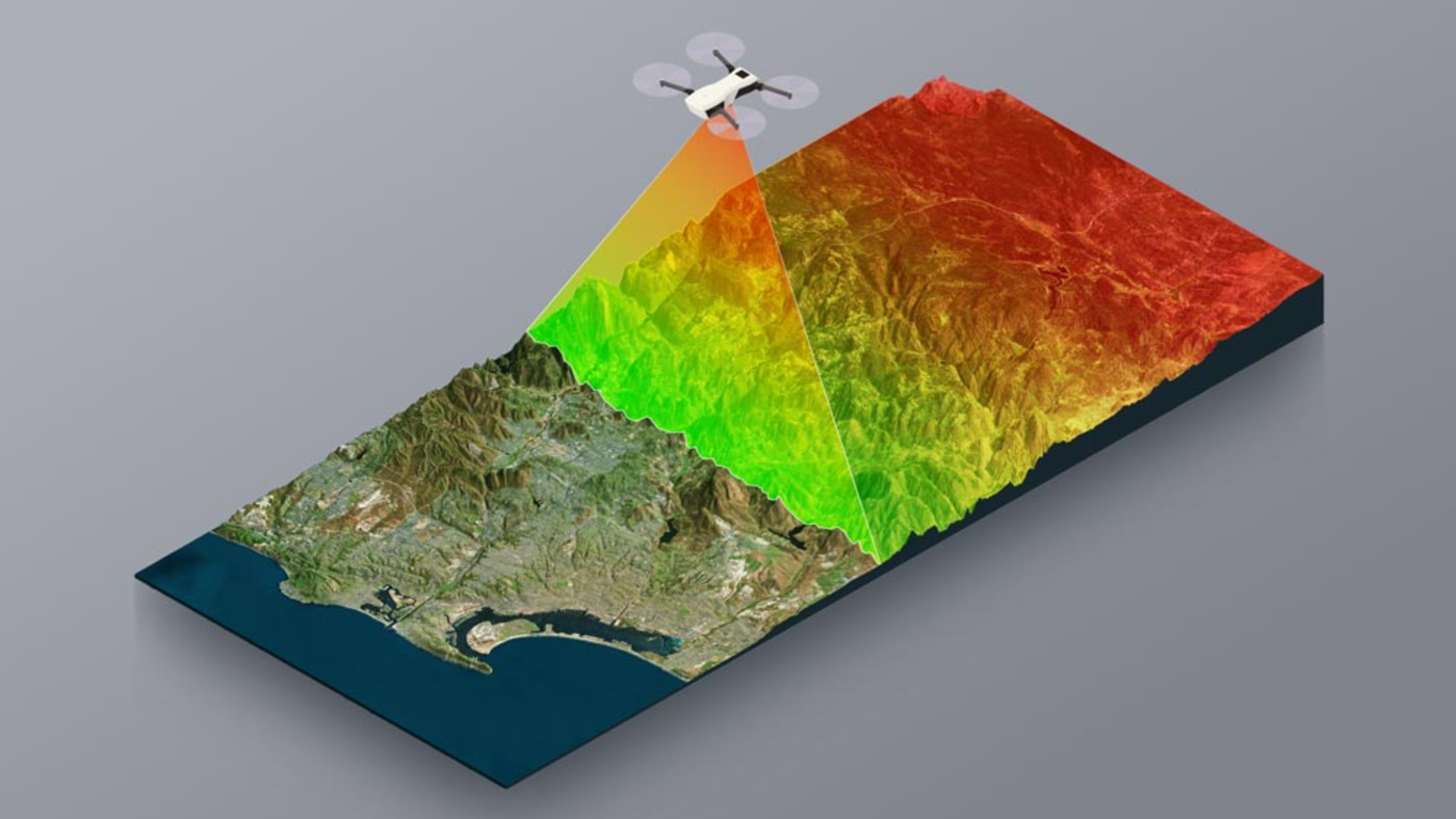
    Our Drone LiDAR Surveys in Imperial harness the power of innovative drone technology to efficiently and accurately map underground utilities, offering a comprehensive view of the subsurface terrain. By utilizing LiDAR technology, we can collect precise data points that enable us to create detailed 3D models and identify potential obstacles or utility line locations with exceptional accuracy.

    Key Features of Our Drone LiDAR Surveys:

    1. High Precision Mapping: Our advanced LiDAR technology ensures precise data collection and mapping of underground utilities.
    2. Efficient Data Collection: Drones enable us to collect data quickly and efficiently, saving time and reducing costs.
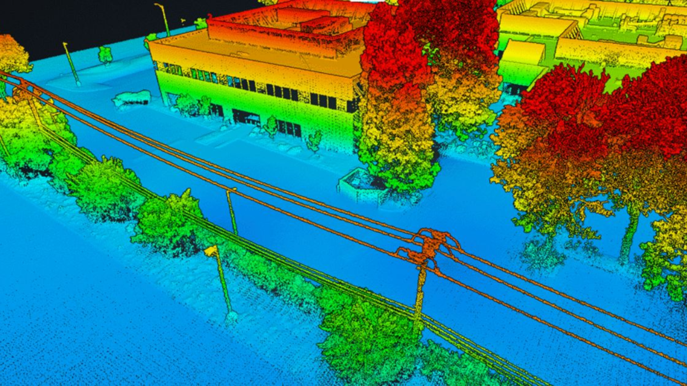
    3. Detailed 3D Modeling: We provide comprehensive 3D models of the surveyed area, offering a clear visualization of underground utilities.
    4. Accurate Location Identification: Our surveys help identify exact locations of utility lines, minimizing the risk of damage during excavation.

    Experience the Devco Advantage

    As a Disabled Veteran Business Enterprise (DVBE), we take pride in our commitment to excellence and integrity in all our services. In addition to being a DVBE, we hold certifications as a Service-Disabled Veteran-Owned Small Business (SDVOSB), Public Works Small Business Enterprise (PDBE), Small Business Enterprise-Micro (SB-Micro), and Small Business-Public Works (SB-PW). These certifications showcase our dedication to quality, diversity, and customer satisfaction in every project we undertake.

    Contact Us Today for Drone LiDAR Surveys in Imperial

    For professional and reliable Drone LiDAR Surveys in Imperial County, trust Devco Development & Engineering to deliver exceptional results. To learn more about our services or inquire about pricing for Drone LiDAR Surveys, visit our website or contact us at (951) 221-3633, or email us at Info@devco-inc.com.

    Experience the expertise of Devco Development & Engineering for all your underground utilities mapping needs in Imperial, California.

    Listing Details
    • Category
      Drone LiDAR Surveys
    • County
      Imperial County
    • City
      Imperial
    • Contact Email
      Info@devco-inc.com
    • Phone Number
      (323) 347-3695
    • Services
      Drone LiDAR Surveys Imperial, Survey Imperial
    Gallery
    Location
    • Imperial, CA, USA

      Get Directions
    Contact Form

        You May Also Be Interested In

        Gallery image Gallery image Gallery image

        Drone LiDAR Surveys Holtville Verified listing

        Underground Utilities - Drone LiDAR Surveys Holtville
        • (323) 347-3695
        • Holtville
        • Imperial County
        • Drone LiDAR Surveys
        • Quick view
        • Bookmark
        Gallery image Gallery image Gallery image

        Drone LiDAR Surveys Niland Verified listing

        Underground Utilities - Drone LiDAR Surveys Niland
        • (323) 347-3695
        • Niland
        • Imperial County
        • Drone LiDAR Surveys
        • Quick view
        • Bookmark
        Gallery image Gallery image Gallery image

        Drone LiDAR Surveys Ocotillo Verified listing

        Underground Utilities - Drone LiDAR Surveys Ocotillo
        • (323) 347-3695
        • Ocotillo
        • Imperial County
        • Drone LiDAR Surveys
        • Quick view
        • Bookmark
        Gallery image Gallery image Gallery image

        Drone LiDAR Surveys Seeley Verified listing

        Underground Utilities - Drone LiDAR Surveys Seeley
        • (323) 347-3695
        • Seeley
        • Imperial County
        • Drone LiDAR Surveys
        • Quick view
        • Bookmark
        Gallery image Gallery image Gallery image

        Drone LiDAR Surveys Westmorland Verified listing

        Underground Utilities - Drone LiDAR Surveys Westmorland
        • (323) 347-3695
        • Westmorland
        • Imperial County
        • Drone LiDAR Surveys
        • Quick view
        • Bookmark
        Gallery image Gallery image Gallery image

        Drone LiDAR Surveys Brawley Verified listing

        Underground Utilities - Drone LiDAR Surveys Brawley
        • (323) 347-3695
        • Brawley
        • Imperial County
        • Drone LiDAR Surveys
        • Quick view
        • Bookmark

        Request for Contact/Quote

        Have an urgent request? Let us know here and we will have someone reach out ASAP.  

        Driving innovation in development and engineering with a multifaceted approach to modern infrastructure solutions.

        Linkedin Facebook Instagram

        Primary Services

        • Hydro Excavation
        • Horizontal Directional Drilling (HDD)
        • Micro Trenching
        • Pipe Bursting & Pipe Splitting
        • Potholing
        • Directional Boring
        • Hydro Vac

        About

        • About Us
        • Blog
        • Careers

        Company Info

        • CSLB #1105687 A & B License
        • AZ ROC #: 352495 (A) - 352644 (B)
        • DVBE, SB-PW, SB-Micro #2034204
        • SDVOSB #J3QDZW55B215
        • DUNS #124830229
        • DIR #1001084629
        • PDBE #23001218
        • Office: (951) 221-3633
        • Email: info@devco-inc.com
        • Corporate Office: Temecula, Ca

        Copyright 2026 © All rights Reserved. Developed By Devco RT, Inc

        m

        Cart

          • Facebook
          • X
          • WhatsApp
          • Telegram
          • LinkedIn
          • Tumblr
          • Reddit
          • VKontakte
          • Mail
          • Copy link
          • Share via...
          • Facebook
          • X
          • WhatsApp
          • Telegram
          • LinkedIn
          • Tumblr
          • Reddit
          • VKontakte
          • Mail
          • Copy link
          • Share via...